1500-Year-Old Lost Roman City of Altinum Rediscovered Through Aerial Mapping
This had been one of the Roman Empire’s richest cities. But when the mighty Germanic Emperor Attila the Hun started his assault in AD452, Altinum’s inhabitants began their great escape and fled.
The once-bustling metropolis, regarded by some scholars as the forerunner of Venice, gradually sank into the ground and obscurity. But now, thanks to sophisticated aerial imagery, the lost city has been brought to life once again more than 1,500 years on.
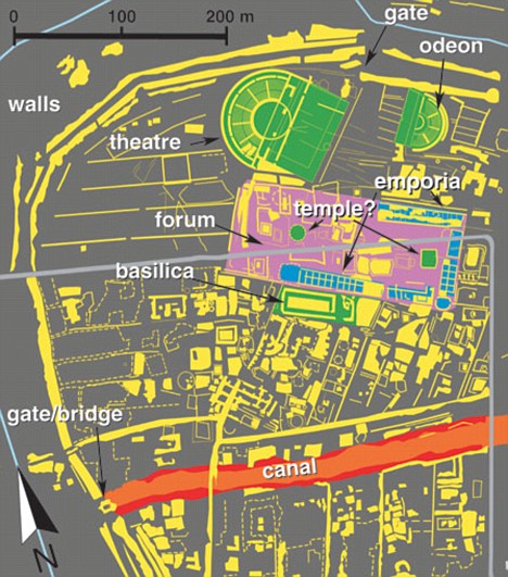
From the ground, the 100-hectare site just north of Italy’s Venice airport looks like nothing more than rolling fields of corn and soybeans. However, researchers have managed to map out the remains of the buried city, revealing a detailed street plan of the city walls, the street network, dwellings, theatres, and other structures.
They also show a complex network of rivers and canals, revealing how the people mastered the marshy environment in what is now the lagoon of Venice.
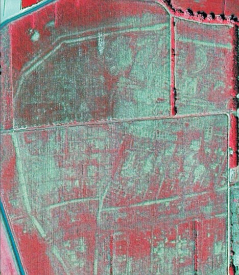
In July 2007 Paolo Mozzi, a geomorphologist at the University of Padua in Italy, and his team took aerial photos of the site in several wavelengths of visible light and near-infrared.
The photos were taken during a severe drought in 2007, which made it possible to pick up the presence of stones, bricks and other solid structures beneath the surface. When the images were processed to tease out subtle variations in plant water stress, a buried metropolis emerged.
The researchers discovered that the crops planted on the land were in different stages of ripening, thanks to differences in the amount of water in the soil. Lighter crops traced the outlines of buildings – including a basilica, an amphitheater, a forum, and what may have been temples – buried at least 40 centimeters below the surface.
To the south of the city center runs a wide strip of riper crops. They were growing above what used to be a canal, an indication that Venice’s Roman forebears were already incorporating waterways into their urban fabric.
The authors note that Altinum, a trading center that thrived between the 1st and 5th centuries AD, is the only large Roman city in northern Italy – and one of the few in Europe – that has not been buried by medieval and modern cities.
Some scholars have described the historic city as the precursor to ancient Venice.
The first-century Roman historian Strabo mentions Altinum’s important location with its heavily travelled sea routes and roads running north to the edges of the Roman Empire making it a critical mercantile center.
But as waves of barbarians invaded, Altinum was a ripe target and, finally, in the 7th century AD, a Lombard invasion pushed the city’s remaining residents onto the surrounding islands of the Venice lagoon.
Most of the ancient city’s stones were stolen in the Middle Ages to be reused elsewhere. Land reclamation efforts in the 19th century turned the area from a marsh into farm fields.
Previous archaeological excavations have focused mainly on the city’s necropolis, located outside the walls, but this is the first-ever glimpse of the city’s layout. Local officials are enthusiastic about the study, which was published in the Science journal.
‘Before what Professor Mozzi has done, it was impossible to imagine the complexity and distribution of the main buildings and structures of the municipium,’ Margherita Tirelli, inspector of the Archaeological Superintendence of Veneto and director of the National Archaeological Museum of Altinum told the journal.
Mozzi and his team are planning further survey work, including scans of the area with a remote-sensing technology known as LIDAR, which will help create a higher-resolution topographic map of the site.
The team also plans to sample soil at the site to see whether environmental conditions, such as flooding or drought, might have contributed to Altinum’s abandonment.
The images will help archaeologists pinpoint the best locations for future excavation.